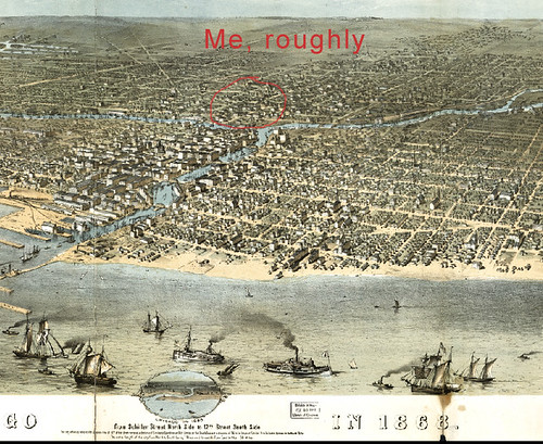
These are very cool! Of course, I picked out places I've been, Chicago (for instance, Chicago in 1868 from Schiller Street north side to 12th Street south side), Austin (nyet), Dallas, New York, San Francisco, Sarnia (Ontario), etc. Sort of a clunky interface, but still fun to browse. Probably especially since D & I have become Deadwood Acolytes (churned through season 1 & 2 via Netflix since July 4th weekend, and halfway through season 3 now. More on that later).

(click to embiggen)
Panoramic Maps from the Library of Congress The panoramic map was a popular cartographic form used to depict U.S. and Canadian cities and towns during the late nineteenth and early twentieth centuries. Known also as bird's-eye views, perspective maps, and aero views, panoramic maps are nonphotographic representations of cities portrayed as if viewed from above at an oblique angle. Although not generally drawn to scale, they show street patterns, individual buildings, and major landscape features in perspective. The majority of items presented here are documented in PANORAMIC MAPS of Cities in the United States and Canada, second edition (1984), by John R. Hébert and Patrick E. Dempsey. Hébert and Dempsey compiled a checklist of 1,726 panoramic maps of U.S. and Canadian cities
Cartography is sort of a lost art form, to our society's detriment. Oh, search form here
I also haven't found any map this warning would be relevant for:
The Library of Congress presents these documents as part of the record of the past. These primary historical documents reflect the attitudes, perspectives, and beliefs of different times. The Library of Congress does not endorse the views expressed in these collections, which may contain materials offensive to some readers.
but I'm still looking. Again, having immersed myself in the world of Deadwood, South Dakota, circa 1876 has helped.
(from 2020 hindsight, via Backup Brain)
Tags: Cartography, /Chicago, /Maps
